
Geological and hydro-geological conditions are determining factors for underground structures, having a very deep impact on the planning and budget necessary to complete the project.
In fact, encountering unforeseen geological aspects may even stop a project or even make it unfeasible. Therefore it is absolutely necessary from the beginning to have an "image" as precise as possible of all characteristics of soils or rocks to be encountered.
This is the main reason why a thorough site investigation of the area where a future underground structure is to be built is essential, reducing risks and allowing more optimized and economical solutions to the problem.
In general, there are several purposes for site investigation, that can summarized as follows:
Purposes of site investigation
-
Support planning and define the project feasibility
- Identify items that may need contingency plans
-
Determine most economical and appropriate
- Route and depth definition
- Excavation and support methods definition
-
Define physical characteristics of the soil, rock, and groundwater
- govern the behavior of the tunnel
- To minimize uncertainties of physical conditions for the bidder & to improve safety
-
Provide specific data needed to evaluate
- constructability
- cost
- productivity
- schedule
-
To document as
- built conditions of the completed project
There are different methods that can be used in order to investigate the hydro-geological conditions of the area where a future underground infrastructure is to be built.
In most projects, several of these methods are used together in order to give an image as close as possible to the reality. Some of these methods are:
Geological Investigation methods
- Gathering of already existing geological data from the area
- Geological surveying of the surface
- Geophysical prospection
- Gravimetric prospection
- Magnetometry prospection
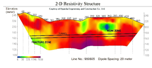
- Electric resistivity prospection
- Electro-magnetism prospection
- Seismic refraction
- Borings (horizontal, vertical or controlled)
Hydrogeological investigation methods
- Gathering of already existing hydrological data from the area
- Hydrological surveying of the surface
- Geophysical prospection
- Resistivity prospection
- Borings
- Permeability measurements
